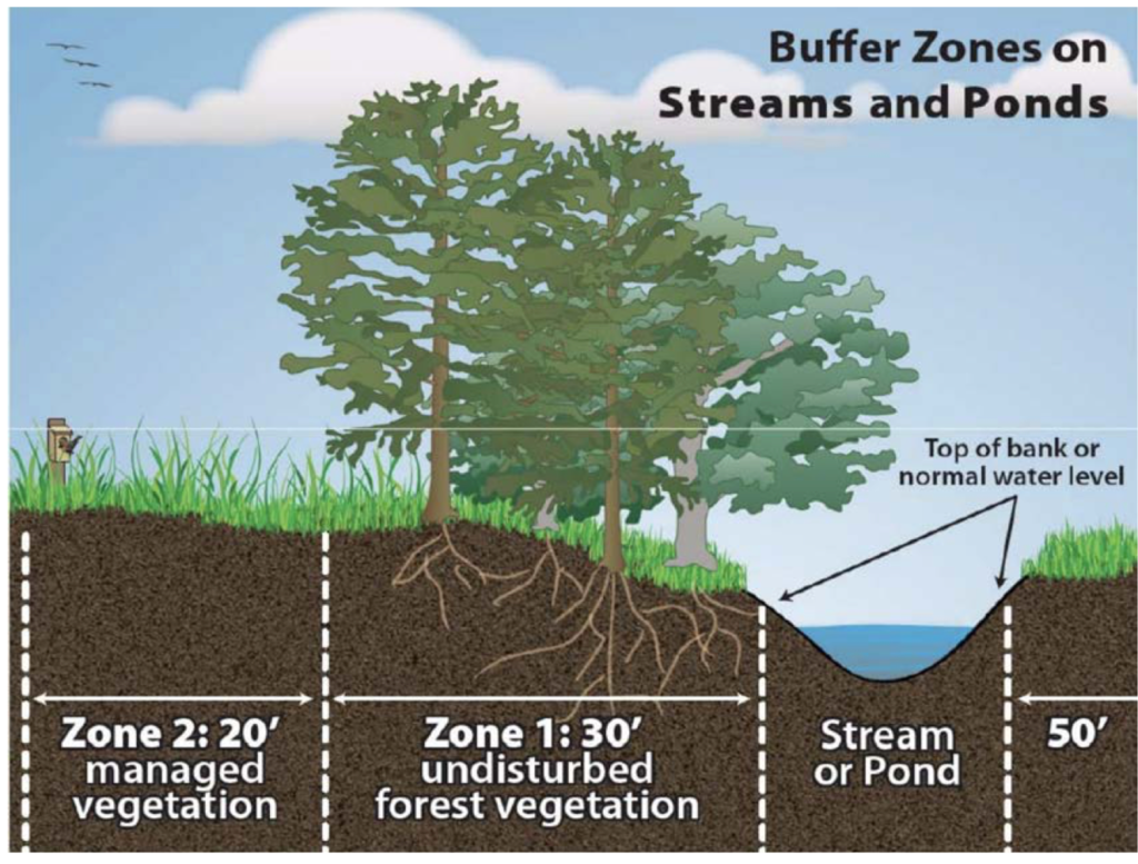
Greenways are great in the right places. There is a big caveat. Pavement does not belong in riparian zones next to a creek. What is a riparian zone? See diagram below.
The 2009 Bolin Creek Greenway Conceptual Master Plan favored the creekside route before an engineering study was conducted. This proposed alignment would run for approximately two miles of trail in the riparian zone next to Bolin Creek, extending from Estes Drive Extension to Homestead Road and take out all the trees and tree roots in its path in the midst of a 425 acre forest. When tree canopy is removed next to a creek, water temperatures rise, and animal and insect populations decline along with water quality.
There are a number of alternative options to the proposed creekside route:
- Upland Forest Alignment – A greenway alternative listed in the 2009 Conceptual Greenway Plan is located outside the floodplain that would direct users to Seawell School Road. This route utilizes existing trail corridors that vary in width from 72 inches to 15 feet.
- Potential Rails to Trail Option – This can happen when UNC abandons reliance on coal, a prospect under consideration and was recommended in the 2020 Revised Bike Plan for Carrboro.
- Neighborhood By-ways – According to the 2025 Revised Bike Plan these routes utilize neighborhood streets such as Cobblestone and Pathway Drive, tying low traffic streets with existing trails leading to the UNC bridge and the power easement.
- Seawell School Off-Road Bike Path – This proposed route is part of the Carolina North Development Agreement between Chapel Hill and UNC. This is the most direct and efficient route for transportation use, tying hundreds of homes on Homestead with the new bike lanes to be built this year on Estes Drive Extension which in turn will tie to Chapel Hill’s Greenway system. This route can also connect with the proposed Campus-to Campus Connector endorsed by UNC, Carrboro and Chapel Hill following the adoption of the UNC Development Agreement. This route is located on land owed by Chapel Hill to the west of the railroad track, and connects Estes Drive by Estes Apartments and connects directly to Downtown Chapel Hill and Carrboro. Both Chapel Hill and Carrboro recommended that the Seawell School Off-Road Bike Path and the Campus-to-Campus Connector be placed on the regional Metropolitan Planning Organization’s (MPO’S) list for funding.
- Connection to Chapel Hill – Chapel Hill is planning more greenways too. The Chapel Hill Greenway/bikepath at Umstead Park could run several routes. The least damaging to Bolin Creek would be to build the bikeway along Umstead Drive to intersect with Estes Drive Extension where new bikeways will be built this year, and then to join the planned off -road Seawell School Bike Path.
Many existing trails and off road bikeways are already available for recreation and some for transportation. Some are in the planning stages.
View this map of the many trails in the Upper Bolin Creek Watershed.
Why oppose the Carrboro Council’s current approach to identifying new greenway routes?
- The Town has not performed due diligence because the “engagement process” underway now began before facts were provided on the available alignments.
- In determining the preferred route, the Council and staff relied on a 14 year old Greenway concept plan – instead of an engineering feasibility study.
- Any multi-million dollar project requires an engineering study that would assess construction costs, environmental impacts, and costs. At this point costs and impacts are unknown.
- The Town has not performed mobility studies for any of the route alignments.
- Challenging topography in the Upper Bolin Creek Watershed would necessitate placing the creekside paved bikeway in the riparian zone of the creek, a clear violation of the Jordan Lake Buffer rules.
- The Neighborhood By-way, the Upland Forest Route, and the Sewell School Road off-road bike path all provide suitable alternatives to the creekside route. If UNC abandons coal, the railroad line also becomes a viable alternative.